This plan focuses on the natural hazards which have historically affected the city and could affect Albany again in the future. It also looks at the potential of hazards of increased magnitude due to climate change.
Plan Documents
- Full Natural Hazard Mitigation Plan (pdf, 460 pages)
- Action Items (pdf)
Plan Summary
Introduction
How have natural hazards affected Albany?
Natural hazards pose a threat to the city’s economy and its residents’ property and health. Natural disasters have caused major problems in Albany’s recent history. Windstorms, heavy rainstorms, wildfires in other communities and ice storms have posed threats within the last 10 years. Albany’s location near a major earthquake subduction zone and faults places it in danger of significant earthquake damage. Flooding is a primary concern to the city due to its location in the Willamette River valley. Planning for natural hazards is vital due to the potential devastating effects on property and the local economy.
Albany has been or could be greatly affected by several natural hazards including windstorms, winter storms, flooding, and earthquakes. Luckily, landslides and wildfires are limited within the city limits due to a lack of urban interface area and minimal development on slopes but are still a concern. The following is a brief outline of the history of natural disaster events that have recently impacted the city.
Winter Storm: The most recent winter storm events (during the past five years reviewed for this plan update) include an ice storm in 2023 lasting from February 11 to February 15.
Windstorm: A wind event in 2020 was a declared disaster (Presidential Declaration DR-4562). In 2015, between December 6-23, high winds resulted in widespread tree damage and power outages in the South Willamette Valley. This event was Presidential Declaration DR-4258, a severe storm event including high winds, flooding, landslides, and mudslides in other parts of the state.
Flood: Due to Albany’s location along the Calapooia and Willamette Rivers, the city has had many floods going back to the founding of the city. April 6-21, 2019, saw a particularly strong atmospheric river occur, producing anywhere up to 5 inches of rain over a 48-hour period. This heavy rain combined with snow melt from snow received a few weeks prior, caused flooding along many rivers in Western Oregon. The Willamette River near Harrisburg crested at 15.3 feet around 9 AM on April 9th, which is 1.3 feet above flood stage. Albany received assistance as a part of Presidential Declaration DR-4452 for Severe Storm and Flooding damages.
Earthquake: Minor earthquakes have occurred in Albany. On August 18, 1961, a 4.5 magnitude earthquake caused minor damage and several earthquakes outside Albany have produced tremors felt in the city. In 1993, the Scotts Mills earthquake was magnitude 5.7 on the Richter scale. Locally, there are nearby faults that could cause much more damage to the city.
Public Health Emergency: The COVID-19 Pandemic (DR-4499) occurred January 20, 2020 and was the first pandemic declared a natural disaster in Oregon.
 Which hazards should we be most concerned about?
Risk assessment is a process of collecting information and assigning values to risks for the purpose of informing priorities, developing, or comparing courses of action, and informing decision making. In other words, which natural hazards should we focus on when developing a course of action for the city?
Conducting a risk assessment can provide information on the location of hazards, the value of existing land and property in hazard locations, and an analysis of risk to life, property, and the environment that may result from natural hazard events.
Assessment
Assessing our risk
As part of this analysis, the Steering Committee, facilitated by the Emergency Manager, developed risk scores for natural hazards that affect Albany.This method provides a sense of hazard priorities, or relative risk. It does not predict the occurrence of a particular hazard in a community, but it does “quantify” the risk of one hazard compared with another. By doing this analysis, efforts can first be focused where the risk is greatest.
The process:
The Albany NHMP Steering Committee identified which hazards are relevant to the city. Then, the Committee scored each hazard in four categories: history, probability, vulnerability, and maximum threat. Following is the definition and ranking method for each category:
History
(Record of previous occurrences)
- Low: 0–1 event past 100 years,
- Moderate: 2–3 events past 100 years, and
- High: 4+ events past 100 years.
Probability
(Likelihood of future occurrence within a specified period of time)
- Low: one incident likely within 75–100 years,
- Moderate: one incident likely within 35–75 years, and
- High: one incident likely within 10–35 years.
Vulnerability
(Percentage of population and property likely to be affected under an “average” occurrence of the hazard)
- Low: < 1% affected,
- Moderate: 1–10% affected, and
- High: > 10% affected.
Maximum Threat
(Highest percentage of population and property that could be impacted under a worst-case scenario)
- Low: < 5% affected,
- Moderate: 5–25% affected, and
- High: > 25% affected.
These numbers are the calculated using weight factors to determine the overall severity of the hazards.
2022 NHMP Steering Committee Vulnerability Assessment
Completed by the City of Albany NHMP update Steering Committee during meetings held on November 8, 2021 and December 13, 2021. Based on the Oregon Department of Emergency Management (OEM) methodology combining factors of History, Probability, Vulnerability and Maximum Threat to assess risk. Further information upon request.
|
Hazard |
History |
Probability |
Vulnerability |
Max. Threat |
Risk Score |
|
Ice Storm |
10 |
10 |
10 |
10 |
240 |
|
Snow Storm |
10 |
10 |
10 |
10 |
240 |
|
Ash Fall/Poor Air Quality |
8 |
10 |
10 |
9 |
226 |
|
Wind Storm |
10 |
10 |
9 |
8 |
215 |
|
Public Health Emergency/Pandemic |
8 |
8 |
8 |
10 |
212 |
|
Earthquake |
5 |
6 |
10 |
10 |
202 |
|
Excessive Heat |
10 |
10 |
4 |
8 |
190 |
|
Riverine Flood |
10 |
10 |
4 |
4 |
150 |
|
Wildfire (wildland urban interface fire) |
7 |
8 |
6 |
4 |
140 |
|
Tornado |
4 |
5 |
5 |
7 |
138 |
|
Drought |
1 |
4 |
2 |
2 |
60 |
|
Landslide |
1 |
3 |
1 |
2 |
48 |
During the NHMP update process, the steering committee members identified two additional natural hazards, Excessive Heat and Public Health Emergency/Pandemic, and modified one other.Volcanic eruptions are not a natural hazard experienced in the City of Albany, however, Ash Fall and Poor Air Quality are natural hazards that affect the city.
The previous Natural Hazard Mitigation Plan (NHMP) identified Climate Change as a separate Natural Hazard. The 2022 Steering Committee agreed that the impact of climate change is experienced in the increased severity and frequency of some natural hazard events and should be addressed throughout the NHMP rather than as a discreet natural hazard.
Feedback
Citizen Concerns
The NHMP Steering Committee conducted a survey for citizens in 2021 to collect feedback and risk assessment information from the public during the NHMP update process.This feedback was incorporated into the development of the plan.
The survey effort showed that Wildfire is the natural hazard most people who responded to the survey were most concerned about.
More than 50% of respondents were Concerned or Very Concerned about Earthquake and the City of Albany NHMP Steering Committee also expressed great concern about the vulnerability of the city to earthquake as well as about the maximum threat such a hazard might present.
What natural hazard concerns you and your family the most?
| Hazard (5=extremely concerned, 1=not concerned) | 5 | 4 | 3 | 2 | 1 |
|---|---|---|---|---|---|
|
Drought |
19% |
36% |
22% |
16% |
8% |
|
Earthquake |
21% |
30% |
20% |
23% |
6% |
|
Flood |
9% |
27% |
30% |
26% |
9% |
|
Landslide |
0% |
2% |
12% |
30% |
56% |
|
Volcanic event |
0% |
6% |
14% |
21% |
59% |
|
Wildfire |
34% |
32% |
23% |
8% |
2% |
|
Wind storm |
3% |
33% |
30% |
23% |
10% |
|
Ice/snow storm |
3% |
21% |
36% |
30% |
10% |
Actions
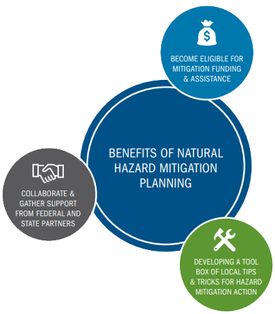
What actions are planned to mitigate or reduce risk from natural hazards?
Forty-five mitigation actions are listed and more fully detailed in the full plan.The table below highlights some of the highest priority or most attainable actions from among that list.
| Action item description | Action type |
|---|---|
|
Develop a Debris Management Plan including strategies for coordinated debris removal following wind and winter storms. |
Plan |
|
Provide educational awareness material to City employees.Provide information on developing emergency plans and assembling 14-day kits. |
Communication |
|
Provide educational and outreach articles to explain how to develop an emergency plan and assemble 14-day kits to residents of Albany. Consider developing an annual public information program to include the multiple educational and outreach actions in the plan. |
Communication |
|
Explore development of program to address seismically deficient buildings |
Plan |
|
Develop specific emergency evacuation or shelter-in-place plans for residential areas that are near significant hazard material storage facilities and heavy industrial areas. |
Communication |
|
Evaluate city emergency transportation routes with City, County and State partners |
Monitoring and Maintenance |
|
Evaluate City-owned bridges to determine which need to be seismically updated and seek appropriate funds.Especially as relates to the primary transportation routes. |
Plan/Analyze |
|
Conduct a vulnerability analysis of Albany’s wastewater collection system to identify elements with the potential for failure in an earthquake, and seek funding for alternatives to seismically retrofit them |
Plan/Analyze |
|
Identify alternative methods for managing wastewater if system elements fail during earthquake. |
Plan |
|
Conduct a vulnerability analysis of Albany water distribution system to identify elements with the potential for failure and seek funding alternatives to seismically retrofit them. |
Plan/Analyze |
|
Identify alternative methods for managing water if system elements fail during earthquake. |
Plan |
|
Develop public/private partnerships to seek outside funding for retrofitting structures in the downtown and historic districts |
Project |
|
Update the Flood and Dam Failure Warning and Response Plan |
Plan |
|
Identify options for safeguarding the aerial fiber optic communications cable that connects the Courthouse with Albany Police Department because it is at risk for damage from high wind events. |
Project |
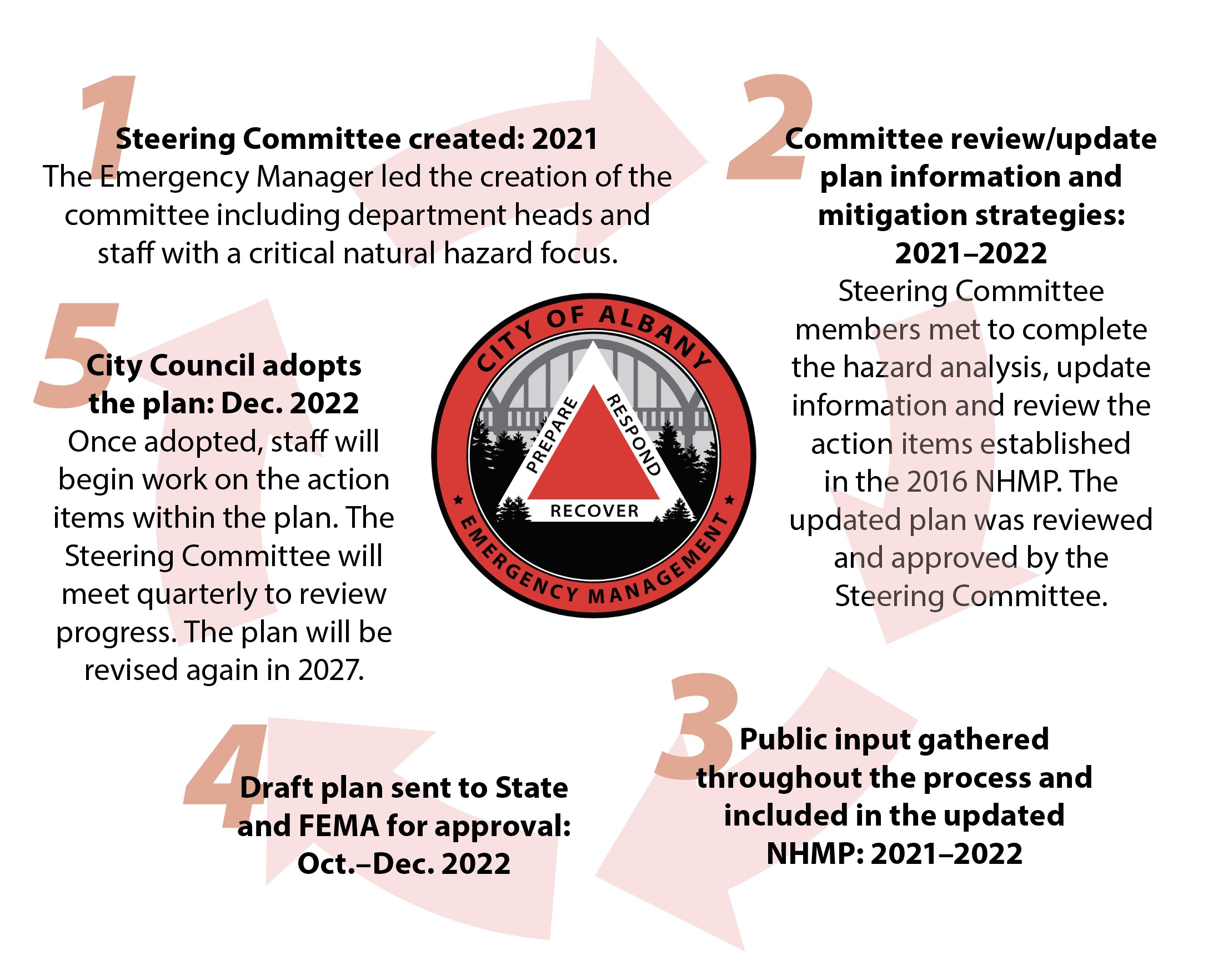
Plan Development
How has the plan been developed? How will it be used beyond 2022?
The Emergency Manger served as the convener for the 2022 NHMP update and established a Steering Committee comprised of city department heads.
Where this plan meets other City priorities
The City of Albany Natural Hazard Mitigation Plan is directly tied to the City’s Strategic Plan and, as a result of this connection, will be implemented through a number of existing plans, programs, and policies including:
- Capital Improvement Program (CIP)
- Central Albany Revitalization Area (CARA) Plan
- Comprehensive Plan
- State Building Codes
The Natural Hazard Mitigation Plan provides a series of recommendations, many of which are closely related to the goals and objectives of these existing planning programs. The Steering Committee is responsible for determining how each individual action will be implemented through existing programs.


